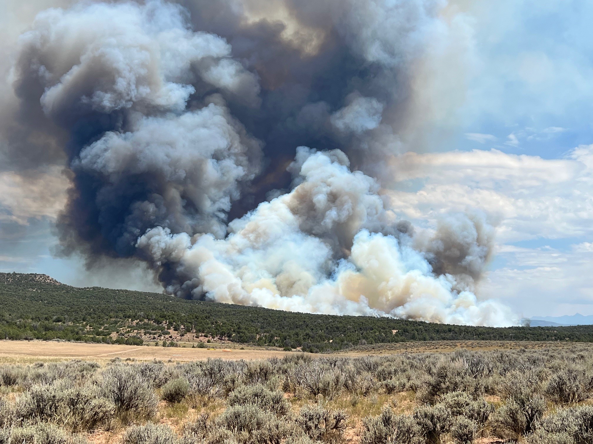
Bucktail Fire Update – August 13, 2024, 12:30 p.m.
Nucla, Colorado
Start Date: August 1, 2024
Cause: Unknown
Size: 7,202 acres
Percent Contained: 83%
Resources Assigned: 112 personnel
Crews (2); Engines (4); Water tenders (1); Air Resources (1); Heavy Equipment (6)
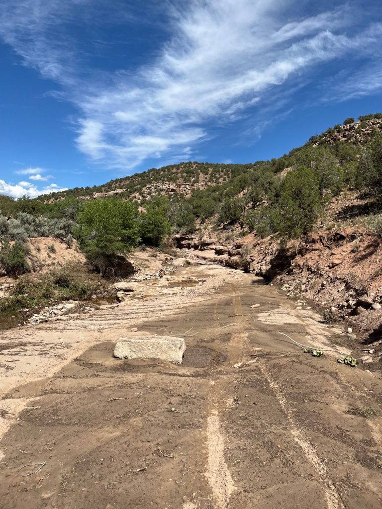
Yesterday: Firefighters transitioned from active fire suppression to repair and patrolling activities. Suppression repair work was carried out to address and restore areas impacted by firefighting operations. Crews continued to clean up and improve control lines along the fire perimeter. While the fire area closure remains in effect, the 25 Mesa Road opened to through traffic.
Today: Rainfall supported firefighter activities in bringing the fire to 83% containment. As a result, firefighters are in the process of demobilization and suppression repair operations are underway. Firefighters will improve the completed fire line and conduct rehabilitation activities such as repairing areas disturbed during fire suppression efforts.
Resources involved in the firefighting and support operations will be demobilized over the course of this week. The demobilization process involves systematically withdrawing equipment and personal that are no longer needed, while ensuring that all necessary tasks are complete and safety measures are in place. Some firefighters will remain in the area to monitor the fire perimeter. This will be the last fire update unless something significant happens.
Weather: There could be several rounds of storms throughout the day. Each could bring heavy rainfall and strong winds. Today’s temperatures will range from 76-81 degrees Fahrenheit while relative humidity will be 42-47%.
Evacuations: None.
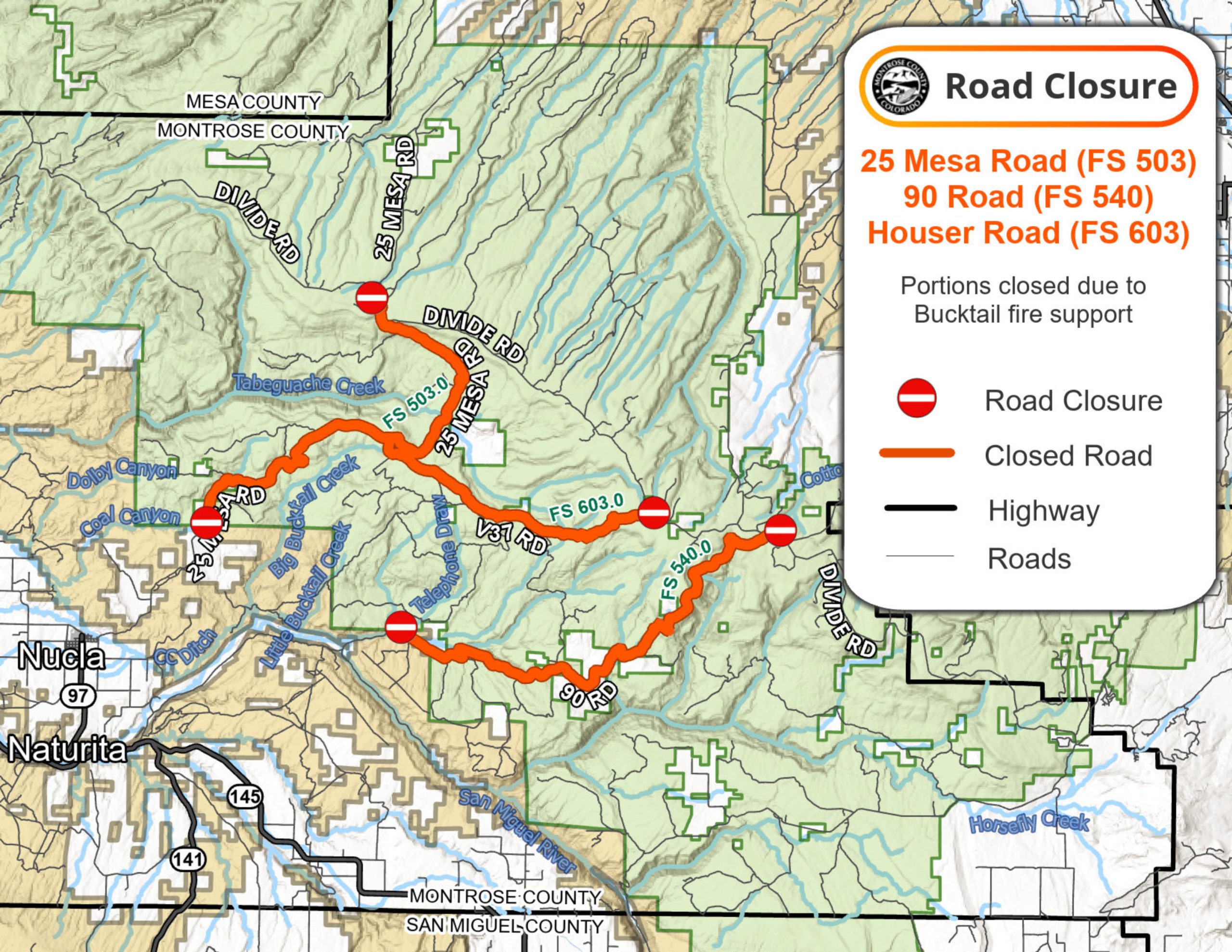
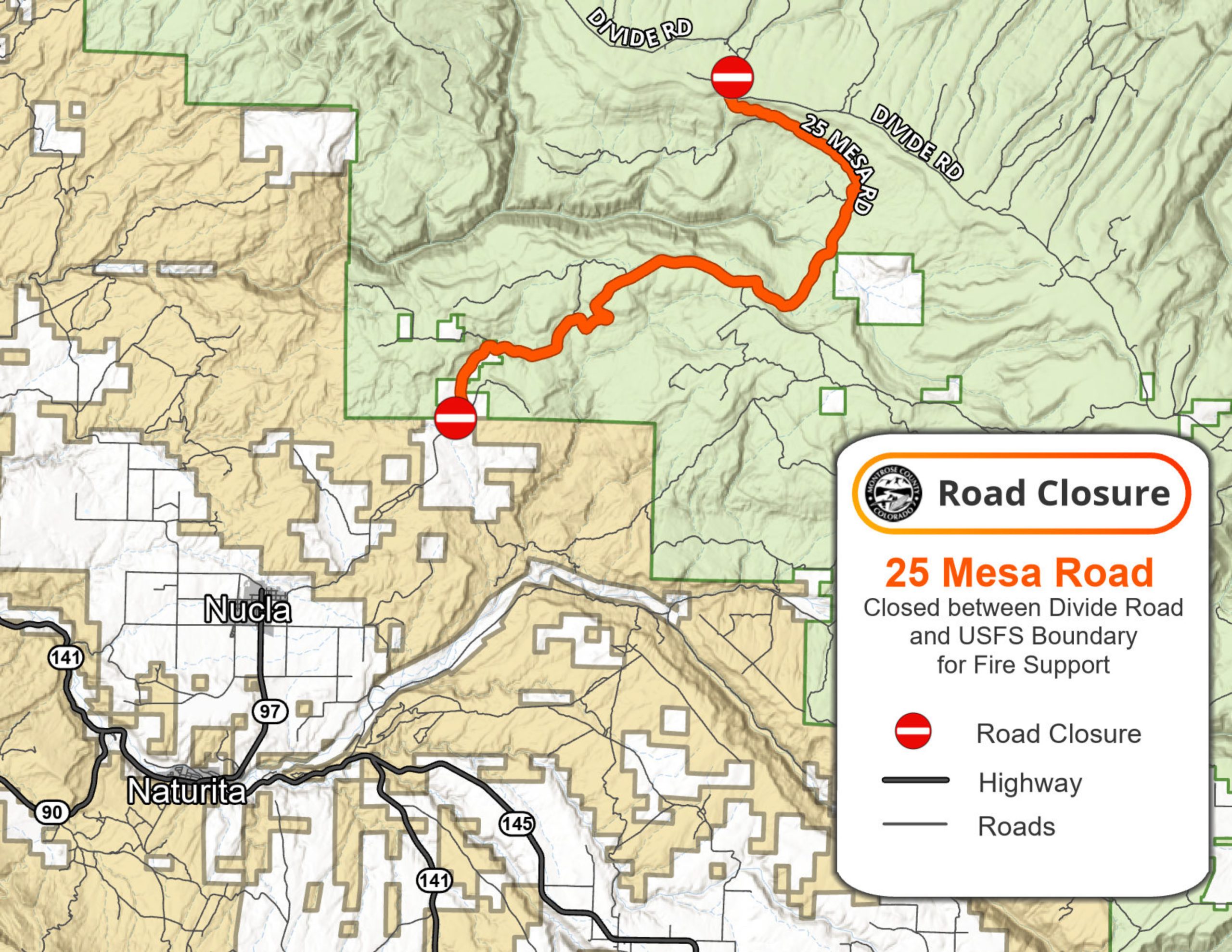
Closures: While the area closure remains in effect, Highway 90 and the 25 Mesa Road is open to through traffic. Road and area closures within the proximity of the fire area remain closed. This includes Houser Road and Cottonwood Trail. For a complete list of closed roads and a map of the closure area, please visit: https://inciweb.wildfire.gov/incident-information/coupd-bucktail-fire.
Authorities will continue to evaluate road conditions in the affected area to determine the best approach for reopening other roads in the future.
The BLM temporary Emergency Closure Order and map are posted to the BLM Southwest District Fire page under Current Fire Restrictions & Notices / Uncompahgre Field Office at: https://www.blm.gov/programs/public-safety-and-fire/fire-and-aviation/regional-information/colorado/southwest-district.
The Forest Service temporary Emergency Closure Order and map are posted on the Forest Service Website at: fs.usda.gov/Internet/FSE_DOCUMENTS/fseprd1198456.pdf. For information about Bucktail fire Forest Service road closures, please contact the Norwood Ranger District at (970) 327-4261.
Smoke Information: Visit CDPHE – Colorado.gov/AirQuality to learn about protecting yourself from wildfire smoke. For more information on current air quality go to Fire and Smoke Map (airnow.gov) and zoom in on Southwest Colorado.
Fire Prevention: Fire managers would like to remind everyone to be attentive to their actions and surroundings, especially in areas with dry vegetation or dead/down trees. Preventing new fires is the most important thing anyone can do to help firefighters. Practice smart wildfire prevention behavior including never leaving a campfire unattended, and ensuring fires are completely out and cold. Make sure trailer chains don’t drag and dispose of smoking materials properly. Every spark can start a fire!
For additional information:
Montrose County Sheriff’s Office: https://montrosecountysheriffsoffice.com/bucktail-fire
Colorado Division of Fire Prevention and Control: https://dfpc.colorado.gov
Bureau of Land Management Southwest Colorado District, Uncompahgre Field Office: https://www.facebook.com/BLMMontroseFireUnit
West Slope Fire Information website: www.WestSlopeFireInfo.com
GMUG Fire Information https://www.facebook.com/GMUGFireInfo
Road Closures Montrose County: https://www.facebook.com/MontroseCountySO
Colorado Department of Transportation: www.cotrip.org
Bucktail Fire Information Hotline: (970) 823-4060
Grand Mesa, Uncompahgre and Gunnison (GMUG) National Forests Hotline (970) 874-6602

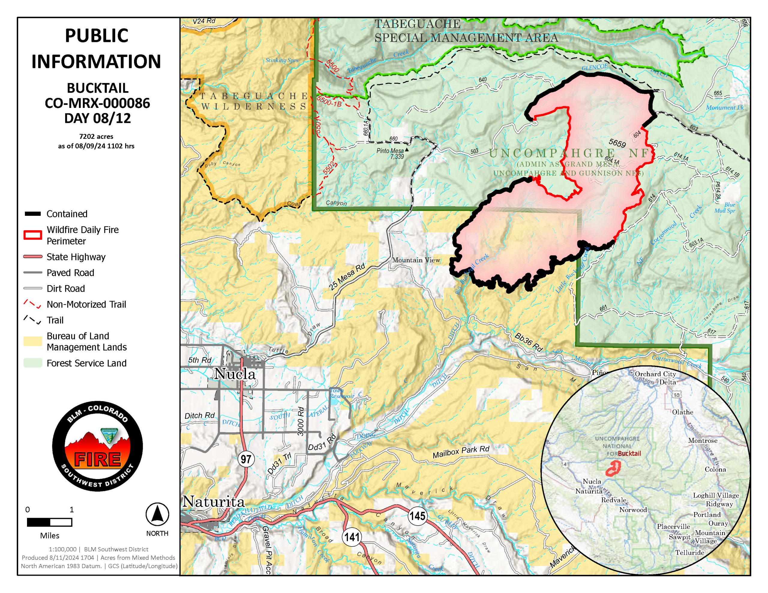
Bucktail Fire Update – August 12, 2024, 11:00 a.m.
Nucla, Colorado
Start Date: August 1, 2024
Cause: Unknown
Size: 7,202 acres
Percent Contained: 67%
Resources Assigned: 110 personnel
Crews (2); Engines (4); Water tenders (1); Air Resources (1); Heavy Equipment (4)
Yesterday: The fire area stayed within its current footprint and rainfall helped reduce the fire intensity within the interior. Crews continued to secure containment lines. Firefighters transitioned from active suppression to repair and patrolling activities. Suppression repair efforts occurred with crews using heavy equipment and hand tools to return impacts caused by firefighting activities to a more natural state. Some firefighters were reassigned to other wildfires in the nation needing support.
Today: Firefighters continue cleaning up, patrolling and monitoring the fire perimeter. Suppression repair work is being carried out to address and restore areas impacted by firefighting operations. While the number of personnel on the fire will continue to decrease significantly over the next couple days, resources will remain on scene to monitor the fire perimeter.
Highway 90 is open to through traffic. While the area closure remains in effect, at 8:00p.m. today, August 12, 2024, the 25 Mesa Road will also open to through traffic. There are active operations on this road with crews and heavy equipment, such as excavators. Please stay alert. The roads and trails north of Highway 90 in the fire area remain closed. Authorities will continue to evaluate road conditions in the affected area to determine the best approach for reopening other roads in the future.
Weather: Lingering showers are possible Monday morning. Scattered showers and thunderstorms redevelop over the higher terrain Monday afternoon. Storms will be capable of producing gusty winds to 40mph. Today’s temperatures will range from 76-81 degrees Fahrenheit while relative humidity will be 40-45%.
Evacuations: None.
Closures: While the area closure remains in effect, Highway 90 is open to through traffic. At 8:00p.m. August 12, 2024, the 25 Mesa Road will open to through traffic. The roads and trails north of Highway 90 in the fire area remain closed.
Road and area closures are in place within the proximity of the fire for public and firefighter safety. This includes 25 Mesa Road to the northwest, as well as Houser Road, Cottonwood Trail, and Hwy 90 to the south. The closure area also includes all roads and trails within this boundary. For a complete list of closed roads and a map of the closure area, please visit: https://inciweb.wildfire.gov/incident-information/coupd-bucktail-fire.
The BLM temporary Emergency Closure Order and map are posted to the BLM Southwest District Fire page under Current Fire Restrictions & Notices / Uncompahgre Field Office at: https://www.blm.gov/programs/public-safety-and-fire/fire-and-aviation/regional-information/colorado/southwest-district.
The Forest Service temporary Emergency Closure Order and map are posted on the Forest Service Website at: fs.usda.gov/Internet/FSE_DOCUMENTS/fseprd1198456.pdf.
A Temporary Flight Restriction (TFR) is in place over the fire area. Wildfires are a No Drone Zone. If You Fly, We Can’t: https://knowbeforeyoufly.org/home
Smoke Information: Visit CDPHE – Colorado.gov/AirQuality to learn about protecting yourself from wildfire smoke. For more information on current air quality go to Fire and Smoke Map (airnow.gov) and zoom in on Southwest Colorado.
Fire Prevention: Fire managers would like to remind everyone to be attentive to their actions and surroundings, especially in areas with dry vegetation or dead/down trees. Preventing new fires is the most important thing anyone can do to help firefighters. Practice smart wildfire prevention behavior including never leaving a campfire unattended, and ensuring fires are completely out and cold. Make sure trailer chains don’t drag and dispose of smoking materials properly. Every spark can start a fire!
For additional information:
Montrose County Sheriff’s Office: https://montrosecountysheriffsoffice.com/bucktail-fire
Colorado Division of Fire Prevention and Control: https://dfpc.colorado.gov
Bureau of Land Management Southwest Colorado District, Uncompahgre Field Office: https://www.facebook.com/BLMMontroseFireUnit
West Slope Fire Information website: www.WestSlopeFireInfo.com
GMUG Fire Information https://www.facebook.com/GMUGFireInfo
Road Closures Montrose County: https://www.facebook.com/MontroseCountySO
Bucktail Fire Information Hotline: (970) 823-4060
Bucktail Fire Update – August 11, 2024, 9:30 a.m.
Nucla, Colorado
Start Date: August 1, 2024
Cause: Unknown
Size: 7,202 acres
Percent Contained: 60%
Resources Assigned: 121 personnel
Crews (2); Engines (5); Water tenders (2); Air Resources (2); Heavy Equipment (3)
Yesterday: Rain helped tamp down fire behavior which assisted firefighters to reach 60% containment on the 7,202-acre fire. Crews strengthened containment lines and patrolled the fire perimeter. Firefighters worked on suppression repair work, which involves a series of actions taken to mitigate impacts caused by firefighting activities. While the fire area closure remains in effect, Highway 90 was opened to through traffic. The roads and trails north of Highway 90 in the fire area remain closed.
Today: Fire behavior continues to decrease and is staying within its current footprint with less smoke anticipated. Firefighters are patrolling the area, securing containment lines, and mopping up hot spots. Suppression repair efforts continue with crews using heavy equipment and hand tools to return impacts caused by firefighting activities to a more natural state. While the number of personnel on the fire will continue to decrease significantly over the next few days, resources will remain on scene to assist and complete any remaining work on the fire line.
Weather: Monsoon moisture remains in place for the next few days through early next week, resulting in more widespread showers and storms capable of heavy rain, frequent lightning and gusty winds. Today’s temperatures will range from 78-83 degrees Fahrenheit while relative humidity will be 39-44%.
Evacuations: None.
Closures: While the area closure remains in effect, Highway 90 is open to through traffic at 12:01 a.m., August 10, 2024. The roads and trails north of Highway 90 in the fire area remain closed.
Road and area closures are in place within the proximity of the fire for public and firefighter safety. This includes 25 Mesa Road to the northwest, as well as Houser Road, Cottonwood Trail, and Hwy 90 to the south. The closure area also includes all roads and trails within this boundary. For a complete list of closed roads and a map of the closure area, please visit: https://inciweb.wildfire.gov/incident-information/coupd-bucktail-fire.
The BLM temporary Emergency Closure Order and map are posted to the BLM Southwest District Fire page under Current Fire Restrictions & Notices / Uncompahgre Field Office at: https://www.blm.gov/programs/public-safety-and-fire/fire-and-aviation/regional-information/colorado/southwest-district.
The Forest Service temporary Emergency Closure Order and map are posted on the Forest Service Website at: fs.usda.gov/Internet/FSE_DOCUMENTS/fseprd1198456.pdf.
A Temporary Flight Restriction (TFR) is in place over the fire area. Wildfires are a No Drone Zone. If You Fly, We Can’t: https://knowbeforeyoufly.org/home
Smoke Information: Visit CDPHE – Colorado.gov/AirQuality to learn about protecting yourself from wildfire smoke. For more information on current air quality go to Fire and Smoke Map (airnow.gov) and zoom in on Southwest Colorado.
Fire Prevention: Fire managers would like to remind everyone to be attentive to their actions and surroundings, especially in areas with dry vegetation or dead/down trees. Preventing new fires is the most important thing anyone can do to help firefighters. Practice smart wildfire prevention behavior including never leaving a campfire unattended, and ensuring fires are completely out and cold. Make sure trailer chains don’t drag and dispose of smoking materials properly. Every spark can start a fire!
For additional information:
Montrose County Sheriff’s Office: https://montrosecountysheriffsoffice.com/bucktail-fire
Colorado Division of Fire Prevention and Control: https://dfpc.colorado.gov
Bureau of Land Management Southwest Colorado District, Uncompahgre Field Office: https://www.facebook.com/BLMMontroseFireUnit
West Slope Fire Information website: www.WestSlopeFireInfo.com
GMUG Fire Information https://www.facebook.com/GMUGFireInfo
Road Closures Montrose County: https://www.facebook.com/MontroseCountySO
Bucktail Fire Information Hotline: (970) 823-4060

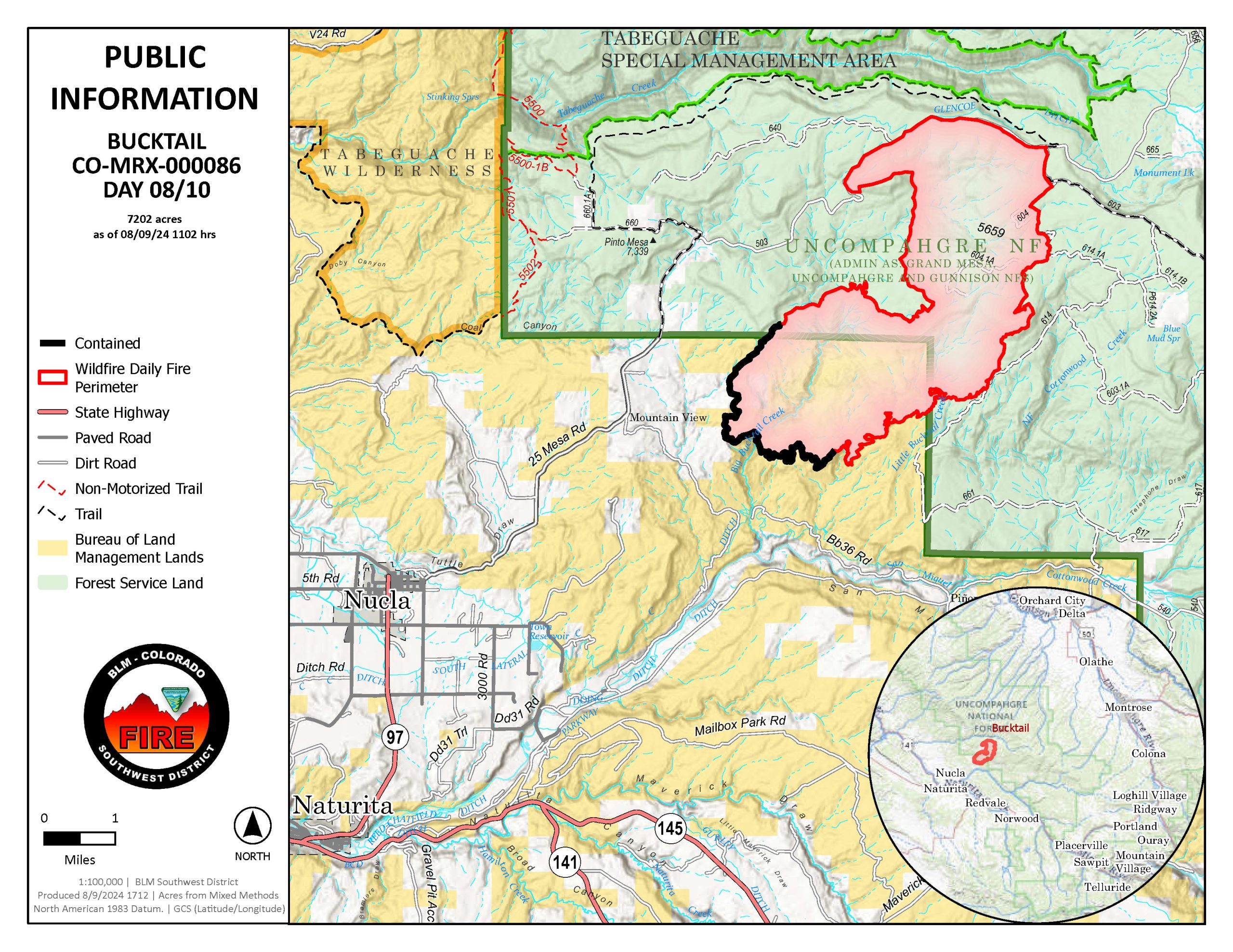
Bucktail Fire Update – August 10, 2024, 11:00 a.m.
Nucla, Colorado
Start Date: August 1, 2024
Cause: Unknown
Size: 7,202 acres
Percent Contained: 10%
Resources Assigned: 193 personnel
Crews (5); Engines (4); Water tenders (2); Air Resources (4); Heavy Equipment (6)
Yesterday: Firefighters made substantial progress in utilizing hand and aerial burnout operations to introduce low intensity fire into available fuels and hold the fire within containment lines. The significant fire growth is due to these operations. Part of their tactics included utilizing a fire scar from 2022 on the northwest side of the fire to moderate fire behavior. Completing the burnout operations marks a crucial milestone in firefighting efforts by securing the perimeter of the fire. Scattered rain occurred across the fire last night, helping moderate fire intensity.
Today: While interior areas of the fire continue to burn, the public should expect to see less smoke today. Crews will continue to hold fire lines, monitor and patrol the area. Containment numbers are expected to increase after crews verify the line on the ground. While the area closure remains in effect, Highway 90 is now open to through traffic. The roads and trails north of Highway 90 in the fire area remain closed.
Weather: Monsoon moisture will remain over the wildfire and allow some showers and thunderstorms to form through the weekend. The chance for heavy rain is 40%. Today’s temperatures will range from 81-86 degrees Fahrenheit while relative humidity will be 31-36%.
Evacuations: None.
Closures: While the area closure remains in effect, Highway 90 is open to through traffic at 12:01 a.m., August 10, 2024. The roads and trails north of Highway 90 in the fire area remain closed.
Road and area closures are in place within the proximity of the fire for public and firefighter safety. This includes 25 Mesa Road to the northwest, as well as Houser Road, Cottonwood Trail, and Hwy 90 to the south. The closure area also includes all roads and trails within this boundary. For a complete list of closed roads and a map of the closure area, please visit: https://inciweb.wildfire.gov/incident-information/coupd-bucktail-fire.
The BLM temporary Emergency Closure Order and map are posted to the BLM Southwest District Fire page under Current Fire Restrictions & Notices / Uncompahgre Field Office at: https://www.blm.gov/programs/public-safety-and-fire/fire-and-aviation/regional-information/colorado/southwest-district.
The Forest Service temporary Emergency Closure Order and map are posted on the Forest Service Website at: fs.usda.gov/Internet/FSE_DOCUMENTS/fseprd1198456.pdf.
A Temporary Flight Restriction (TFR) is in place over the fire area. Wildfires are a No Drone Zone. If You Fly, We Can’t: https://knowbeforeyoufly.org/home
Smoke Information: Visit CDPHE – Colorado.gov/AirQuality to learn about protecting yourself from wildfire smoke. For more information on current air quality go to Fire and Smoke Map (airnow.gov) and zoom in on Southwest Colorado.
Fire Prevention: Fire managers would like to remind everyone to be attentive to their actions and surroundings, especially in areas with dry vegetation or dead/down trees. Preventing new fires is the most important thing anyone can do to help firefighters. Practice smart wildfire prevention behavior including never leaving a campfire unattended, and ensuring fires are completely out and cold. Make sure trailer chains don’t drag and dispose of smoking materials properly. Every spark can start a fire!
For additional information:
Montrose County Sheriff’s Office: https://montrosecountysheriffsoffice.com/bucktail-fire
Colorado Division of Fire Prevention and Control: https://dfpc.colorado.gov
Bureau of Land Management Southwest Colorado District, Uncompahgre Field Office: https://www.facebook.com/BLMMontroseFireUnit
West Slope Fire Information website: www.WestSlopeFireInfo.com
GMUG Fire Information https://www.facebook.com/GMUGFireInfo
Road Closures Montrose County: https://www.facebook.com/MontroseCountySO
Bucktail Fire Information Hotline: (970) 823-4060
Bucktail Fire Update – August 9, 2024, 1:00 p.m.
Nucla, Colorado
Start Date: August 1, 2024
Cause: Unknown
Size: 7,177 acres
Percent Contained: 10%
Resources Assigned: 193 personnel
Crews (8); Engines (5); Water tenders (2); Air Resources (4); Heavy Equipment (7)
Yesterday: With the secured line in place, fire crews successfully conducted hand and aerial ignitions on the northwestern side of the fire. Helicopters continued interior burning into the evening which supported a low intensity fire to reduce understory vegetation. This method of igniting fires and burnout operations controls the speed, intensity, and overall fire behavior. The significant fire growth is due to these operations.
Today: Firefighters and helicopters will continue to scout for burnout opportunities and hand igntions will continue as possible. Expect additional smoke again this afternoon from these operations. Firefighters will continue to strengthen firelines and increase containment. Road and area closures will remain in place throughout the weekend.
Weather: Monsoon moisture increases today and will remain elevated through the coming week. Storms will be capable of strong and unpredictable outflow winds along with an increasing potential for excessive rainfall. Today’s temperatures will range from 81-86F while relative humidity will be 30-35%.
Evacuations: None.
Closures: Road and area closures are in place within the proximity of the fire for public and firefighter safety. This includes 25 Mesa Road to the northwest, as well as Houser Road, Cottonwood Trail, and Hwy 90 to the south. The closure area also includes all roads and trails within this boundary. For a complete list of closed roads and a map of the closure area, please visit: https://inciweb.wildfire.gov/incident-information/coupd-bucktail-fire.
The BLM temporary Emergency Closure Order and map are posted to the BLM Southwest District Fire page under Current Fire Restrictions & Notices / Uncompahgre Field Office at: https://www.blm.gov/programs/public-safety-and-fire/fire-and-aviation/regional-information/colorado/southwest-district.
The Forest Service temporary Emergency Closure Order and map are posted on the Forest Service Website at: fs.usda.gov/Internet/FSE_DOCUMENTS/fseprd1198456.pdf.
A Temporary Flight Restriction (TFR) is in place over the fire area. Wildfires are a No Drone Zone. If You Fly, We Can’t: https://knowbeforeyoufly.org/home
Smoke Information: Visit CDPHE – Colorado.gov/AirQuality to learn about protecting yourself from wildfire smoke. For more information on current air quality go to Fire and Smoke Map (airnow.gov) and zoom in on Southwest Colorado.
Fire Prevention: Fire managers would like to remind everyone to be attentive to their actions and surroundings, especially in areas with dry vegetation or dead/down trees. Preventing new fires is the most important thing anyone can do to help firefighters. Practice smart wildfire prevention behavior including never leaving a campfire unattended, and ensuring fires are completely out and cold. Make sure trailer chains don’t drag and dispose of smoking materials properly. Every spark can start a fire!
For additional information:
Montrose County Sheriff’s Office: https://montrosecountysheriffsoffice.com/bucktail-fire
Colorado Division of Fire Prevention and Control: https://dfpc.colorado.gov
Bureau of Land Management Southwest Colorado District, Uncompahgre Field Office: https://www.facebook.com/BLMMontroseFireUnit
West Slope Fire Information website: www.WestSlopeFireInfo.com
GMUG Fire Information https://www.facebook.com/GMUGFireInfo
Road Closures Montrose County: https://www.facebook.com/MontroseCountySO
Bucktail Fire Information Hotline: (970) 823-4060
Bucktail Fire Update – August 8, 2024, 1:00 p.m.
Nucla, Colorado
Start Date: August 1, 2024
Cause: Unknown
Size: 4,206 acres
Percent Contained: 10%
Resources Assigned: 193 personnel
Crews (8); Engines (7); Water tenders (2); Air Resources (4); Heavy Equipment (6)
Yesterday: Crews continued to prep and secure the hand and dozer lines on the south end of the Bucktail Fire using existing roads and trails. Helicopters contained spot fires when embers landed on the unburned side of the fireline. New total fire growth was minimal.
Today: With the secured line in place, fire crews will conduct hand and aerial ignitions today on the northwestern side of the fire. Firefighters use this method of igniting fires and burnout operations to control the speed, intensity, and overall fire behavior. Expect to see increased smoke due to these fire operations. Helicopters, including a Type 1, will continue water drops on hot spots. Road barricades are in place for firefighter and public safety.
Weather: Above normal heat continues with a decrease in moisture. Scattered showers and thunderstorms, accompanied by gusty, erratic winds, are still possible this afternoon. Temperatures will range between 87-92F while relative humidity will be slightly lower at 15-20%.
Evacuations: None.
Closures: Road and area closures are in place within the proximity of the fire for public and firefighter safety. This includes 25 Mesa Road to the northwest, as well as Houser Road, Cottonwood Trail, and Hwy 90 to the south. The closure area also includes all roads and trails within this boundary. For a complete list of closed roads and a map of the closure area, please visit: https://inciweb.wildfire.gov/incident-information/coupd-bucktail-fire.
The BLM temporary Emergency Closure Order and map are posted to the BLM Southwest District Fire page under Current Fire Restrictions & Notices / Uncompahgre Field Office at: https://www.blm.gov/programs/public-safety-and-fire/fire-and-aviation/regional-information/colorado/southwest-district.
The Forest Service temporary Emergency Closure Order and map are posted on the Forest Service Website at: fs.usda.gov/Internet/FSE_DOCUMENTS/fseprd1198456.pdf.
A Temporary Flight Restriction (TFR) is in place over the fire area. Wildfires are a No Drone Zone. If You Fly, We Can’t: https://knowbeforeyoufly.org/home
Smoke Information: Visit CDPHE – Colorado.gov/AirQuality to learn about protecting yourself from wildfire smoke. For more information on current air quality go to Fire and Smoke Map (airnow.gov) and zoom in on Southwest Colorado.
Fire Prevention: Fire managers would like to remind everyone to be attentive to their actions and surroundings, especially in areas with dry vegetation or dead/down trees. Preventing new fires is the most important thing anyone can do to help firefighters. Practice smart wildfire prevention behavior including never leaving a campfire unattended, and ensuring fires are completely out and cold. Make sure trailer chains don’t drag and dispose of smoking materials properly. Every spark can start a fire!
For additional information:
Montrose County Sheriff’s Office: https://montrosecountysheriffsoffice.com/bucktail-fire
Colorado Division of Fire Prevention and Control: https://dfpc.colorado.gov
Bureau of Land Management Southwest Colorado District, Uncompahgre Field Office: https://www.facebook.com/BLMMontroseFireUnit
West Slope Fire Information website: www.WestSlopeFireInfo.com
GMUG Fire Information https://www.facebook.com/GMUGFireInfo
Road Closures Montrose County: https://www.facebook.com/MontroseCountySO
Bucktail Fire Information Hotline: (970) 823-4060

Bucktail Fire Update – August 7, 2024, 1:30 p.m.
Nucla, Colorado
Start Date: August 1, 2024
Cause: Unknown
Size: 4,155 acres
Percent Contained: 10%
Resources Assigned: 193 personnel
Crews (5); Engines (4); Water tenders (2); Air Resources (4); Heavy Equipment (6)
Yesterday: Crews continued work on hand and dozer lines. Gusting afternoon winds pushed fire beyond 614 Road but air resources responded with water drops to quickly secure the line. New total fire growth was minimal.
Thank you to all who attended the community meeting in Nucla. Additional questions can be directed to 970-823-4060.
Today: Newly arrived hotshot crews will be working on the Northeast side of the fire from the origin to 614 Road. Helicopters, including a Type 1, will continue water drops on hot spots. With the release of resources from other fires in the state, the Bucktail Fire received additional support, bringing the total personnel on scene to 193.
Weather: Afternoon and evening showers and thunderstorms continue. Today’s temperatures will range between 73-83F with wind speeds up to 40 mph. An uptick of monsoonal moisture moves into the region Friday through the weekend, increasing chances of widespread wetting rain.
Evacuations: None.
Closures: Road and area closures are in place within the proximity of the fire for public and firefighter safety. This includes 25 Mesa Road to the northwest, as well as Houser Road, Cottonwood Trail, and Hwy 90 to the south. The closure area also includes all roads and trails within this boundary. For a complete list of closed roads and a map of the closure area, please visit: https://inciweb.wildfire.gov/incident-information/coupd-bucktail-fire.
The BLM temporary Emergency Closure Order and map are posted to the BLM Southwest District Fire page under Current Fire Restrictions & Notices / Uncompahgre Field Office at: https://www.blm.gov/programs/public-safety-and-fire/fire-and-aviation/regional-information/colorado/southwest-district.
The Forest Service temporary Emergency Closure Order and map are posted on the Forest Service Website at: fs.usda.gov/Internet/FSE_DOCUMENTS/fseprd1198456.pdf.
A Temporary Flight Restriction (TFR) is in place over the fire area. Wildfires are a No Drone Zone. If You Fly, We Can’t: https://knowbeforeyoufly.org/home
Smoke Information: Visit CDPHE – Colorado.gov/AirQuality to learn about protecting yourself from wildfire smoke. For more information on current air quality go to Fire and Smoke Map (airnow.gov) and zoom in on Southwest Colorado.
Fire Prevention: Fire managers would like to remind everyone to be attentive to their actions and surroundings, especially in areas with dry vegetation or dead/down trees. Preventing new fires is the most important thing anyone can do to help firefighters. Practice smart wildfire prevention behavior including never leaving a campfire unattended, and ensuring fires are completely out and cold. Make sure trailer chains don’t drag and dispose of smoking materials properly. Every spark can start a fire!
For additional information:
Montrose County Sheriff’s Office: https://montrosecountysheriffsoffice.com/bucktail-fire
Colorado Division of Fire Prevention and Control: https://dfpc.colorado.gov
Bureau of Land Management Southwest Colorado District, Uncompahgre Field Office: https://www.facebook.com/BLMMontroseFireUnit
West Slope Fire Information website: www.WestSlopeFireInfo.com
GMUG Fire Information https://www.facebook.com/GMUGFireInfo
Road Closures Montrose County: https://www.facebook.com/MontroseCountySO
Bucktail Fire Information Hotline: (970) 823-4060

—
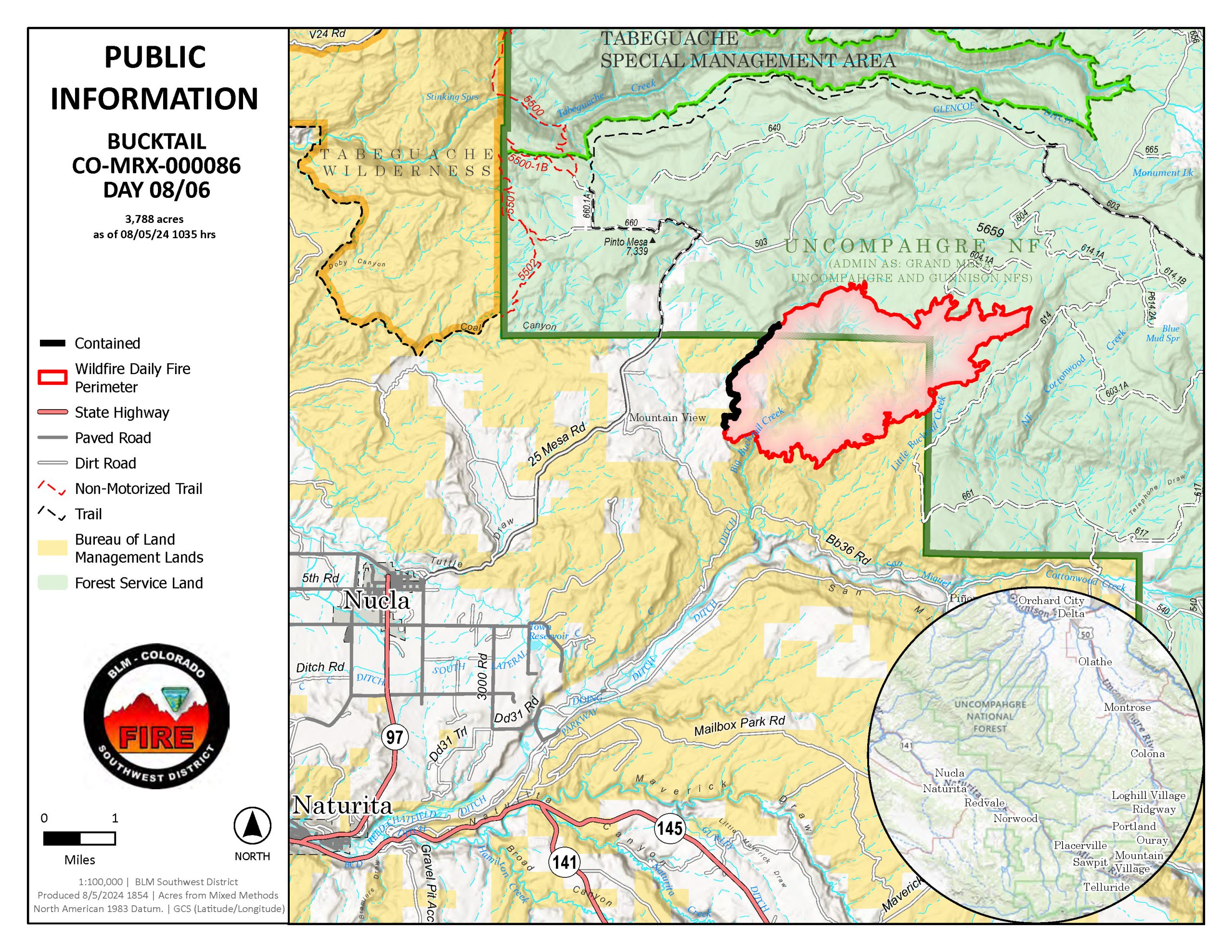
Bucktail Fire Update – August 6, 2024, 2:00 p.m.
Nucla, Colorado
Start Date: August 1, 2024
Cause: Unknown
Size: 3,788 acres
Percent Contained: 10%
Resources Assigned: 134 personnel
Crews (3); Engines (2); Water tenders (2); Air Resources (2); Heavy Equipment (5)
Yesterday: Minimal new growth occurred, primarily along the south and east sides of the fire. Crews continued to work on hand lines while dozers completed a line from the fire origin along the fire’s west side. Afternoon storms brought increased wind and light rain to the area; however, it did not have a noticeable effect on fire activity. Three new fire starts in the region were reported on Monday afternoon.
Today: Ground crews and heavy equipment will continue to strengthen fire lines. Two additional hotshot crews have been ordered and are expected to arrive today. Expect to see more activity in the air as helicopters drop water on hotspots along the fire perimeter.
A community meeting will be held tonight at the Nucla Community Center, located at 1045 Main St., from 6:00 pm to 8:00 pm. Fire managers will give a brief update on fire operations and be available to answer questions.
Weather: Temperatures will range between 75-95F, with above-average humidity due to monsoonal patterns that have developed over the area.Daily afternoon showers and storms are expected each day throughout the weekend. These storms will be capable of producing wetting rain and strong gusty winds between 30-50 mph.
Evacuations: None.
Closures: Road and area closures are in place within the proximity of the fire for public and firefighter safety. This includes 25 Mesa Road to the northwest, as well as Houser Road, Cottonwood Trail, and Hwy 90 to the south. The closure area also includes all roads and trails within this boundary. For a complete list of closed roads and a map of the closure area, please visit: https://inciweb.wildfire.gov/incident-information/coupd-bucktail-fire.
The BLM temporary Emergency Closure Order and map are posted to the BLM Southwest District Fire page under Current Fire Restrictions & Notices / Uncompahgre Field Office at: https://www.blm.gov/programs/public-safety-and-fire/fire-and-aviation/regional-information/colorado/southwest-district.
The FS temporary Emergency Closure Order and map are posted on the FS Website at: fs.usda.gov/Internet/FSE_DOCUMENTS/fseprd1198456.pdf.
A Temporary Flight Restriction (TFR) is in place over the fire area. Wildfires are a No Drone Zone. If You Fly We Can’t: https://knowbeforeyoufly.org/home
Smoke Information: Visit CDPHE – Colorado.gov/AirQuality to learn about protecting yourself from wildfire smoke. For more information on current air quality go to Fire and Smoke Map (airnow.gov) and zoom in on Southwest Colorado.
Fire Prevention: Fire managers would like to remind everyone to be attentive to their actions and surroundings, especially in areas with dry vegetation or dead/down trees. Preventing new fires is the most important thing anyone can do to help firefighters. Practice smart wildfire prevention behavior including never leaving a campfire unattended, and ensuring fires are completely out and cold. Make sure trailer chains don’t drag and dispose of smoking materials properly. Every spark can start a fire!
For additional information:
InciWeb: https://inciweb.wildfire.gov/incident-information/coupd-bucktail-fire
Colorado Division of Fire Prevention and Control: https://dfpc.colorado.gov
Bureau of Land Management Southwest Colorado District, Uncompahgre Field Office: https://www.facebook.com/BLMMontroseFireUnit
West Slope Fire Information website: www.WestSlopeFireInfo.com
GMUG Fire Information https://www.facebook.com/GMUGFireInfo
Road Closures Montrose County: https://www.facebook.com/MontroseCountySO
Bucktail Fire Information Hotline: (970) 823-4060
Bucktail Fire Update – August 5, 2024, 13:30 p.m.
Nucla, Colorado,
Start Date: August 1, 2024
Cause: Unknown
Size: 3,738 acres
Percent Contained: 7%
Resources Assigned: 154 personnel
Crews (6); Engines (3); Water tenders (3); Air Resources (3); Heavy Equipment (4)
Yesterday: The Incident Commander reported that fire behavior has moderated even though thunderstorms brought strong wind gusts for a brief time. The fire growth has been in Ponderosa Pine stands which, along with the brief rain on Sunday, helped moderate fire intensity. Fire line construction continued on the northwest and southeast flank of the fire. Masticators, which are heavy equipment brush cutters, worked to remove brush along critical sections of Mesa Rd 25 which will become sections of fire line. The two helicopters assigned to the fire continued to work to cool hotspots with water drops. Firefighters continued to scout out additional opportunities for fire line locations.
Today: This is day 5 for the Bucktail Fire and operations have moved from initial attack to a longer-term suppression effort. Additional crews, including an eight-person Colorado Division of Fire Prevention and Control (DFPC) fire module, arriving today will add to the fire line construction. Like yesterday, there are two divisions of firefighters. One division is continuing to work northward along the west side and the second division is working eastward along the southeast side. Firefighters will continue to scout for fire line options. Helicopters will continue to drop water on hot spots to check the fire’s spread.
Weather: Scattered thunderstorms in the afternoon. At 8000 ft., temperatures will range from 76-86F with minimum relative humidity 21-31%. At 6000 ft., temperatures will range from 87-97 with minimum relative humidity 15-25%. Winds will be upslope 4-8 mph after 11 a.m. with more erratic and gusty winds where thunderstorms are present.
Evacuations: None.
Closures: Road closures are in place within the area of the fire. County Road 25 Mesa is now closed due to emergency operations on the Bucktail Fire. The closure extends from the 25 Mesa/Divide Road intersection to where the pavement starts on 25 Mesa outside of Nucla. Houser Cow Camp Road is closed, down to Old Highway 90 (https://www.facebook.com/MontroseCountySO). A Temporary Flight Restriction (TFR) is in place over the fire area. Wildfires are a No Drone Zone. If You Fly We Can’t Fly https://knowbeforeyoufly.org/home
Smoke Information: Visit CDPHE – Colorado.gov/AirQuality to learn about protecting yourself from wildfire smoke. For more information on current air quality go to Fire and Smoke Map (airnow.gov) and zoom in on Southwest Colorado.
Fire Prevention: Fire managers would like to remind everyone to be attentive to their actions and surroundings, especially in areas with dry vegetation or dead/down trees. Preventing human-caused fires is the most important thing anyone can do to help firefighters. Please ensure you
dispose of smoking materials properly. Check for local fire restrictions. Practice smart wildfire prevention behavior including never leaving a campfire unattended, and ensuring their fires are completely out and cold. Make sure trail chains don’t drag because, every spark can start a fire!
For additional information:
InciWeb: https://inciweb.wildfire.gov/incident-information/coupd-bucktail-fire
Colorado Division of Fire Prevention and Control: https://dfpc.colorado.gov
Bureau of Land Management Southwest Colorado District, Uncompahgre Field Office: https://www.facebook.com/BLMMontroseFireUnit
West Slope Fire Information website: www.WestSlopeFireInfo.com
GMUG Fire Information https://www.facebook.com/GMUGFireInfo
Road Closures Montrose County: https://www.facebook.com/MontroseCountySO
Bucktail Fire Information Hotline: (970) 823-4060.
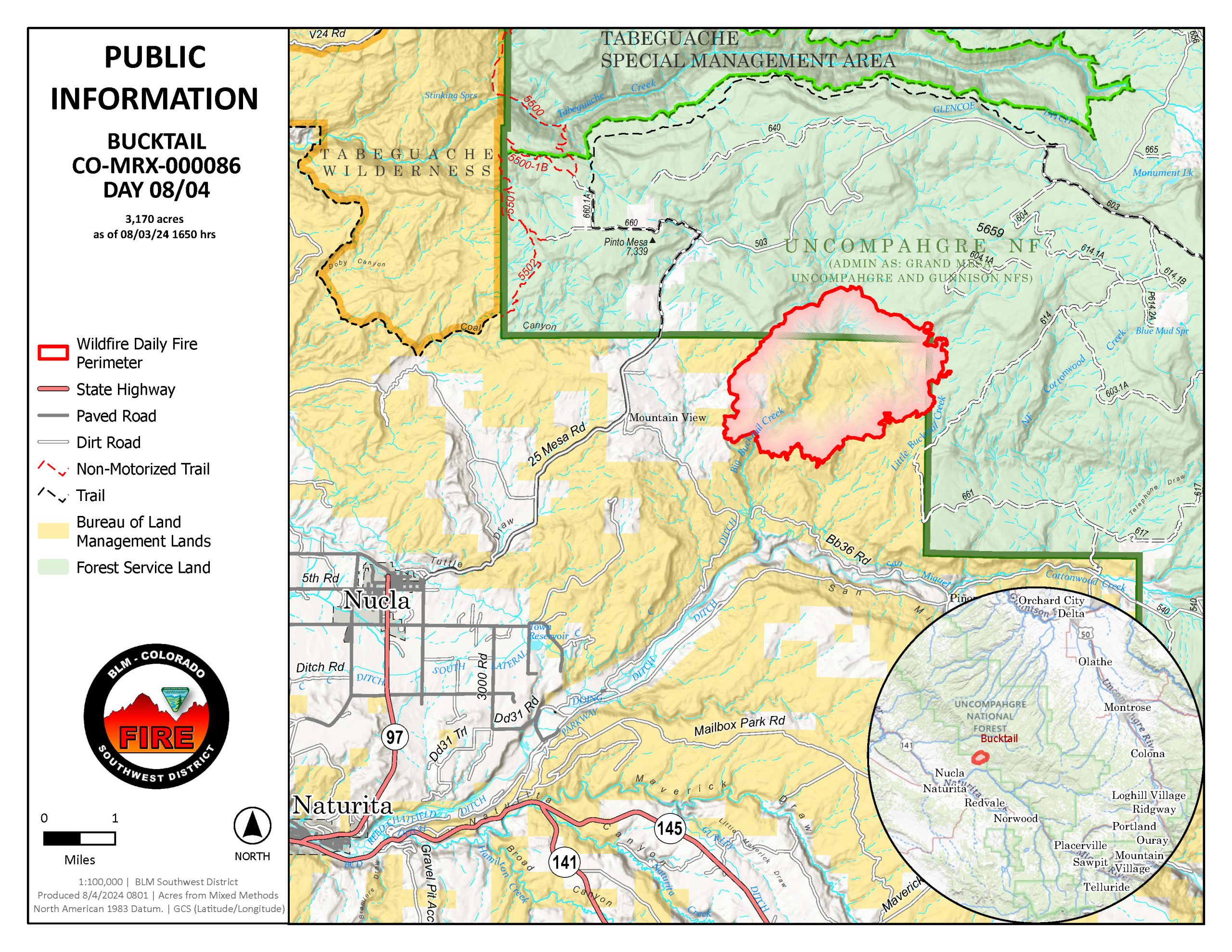
Bucktail Fire Update – August 4, 2024, 11:00 a.m.
Nucla, Colorado,
Start Date: August 1, 2024
Cause: Unknown
Size: 3,170 acres
Percent Contained: 5%
Resources Assigned: 154 personnel
Crews (4); Engines (6); Water tenders (2); Air Resources (3); Heavy Equipment (5)
Special Thank you to the local communities. Your support has been amazing!
Yesterday: On the west flank of the fire, firefighters continued to build fire line northward. Along the southern flank, fire fighters built fire line toward Bucktail Creek. Two helicopters worked to cool hotspots with water drops. Firefighters scouted out fire line locations for the next day’s work. While the fire grew approximately 200 acres yesterday, the growth slowed significantly from the previous day’s due to firefighters work and weather changes.
Today: Like yesterday, there are two divisions of firefighters. One division is continuing to work northward along the west side and the second division is working eastward along the southeast side. Firefighters will continue to scout for fire line options. Helicopters will continue to drop water on hot spots to check the fire’s spread. Fire managers anticipate this to continue for the next several days.
Weather: Partly cloudy till noon. Scattered showers and thunderstorms. At 8000 ft. temperatures will range from 73-83F with minimum relative humidity 22-32%. At 6000 ft. temperatures will range from 86-96 with minimum relative humidity 16-26%. Winds will be upslope 4-8 mph after 11 a.m. with more erratic and gusty winds where thunderstorms are present.
Evacuations: None.
Closures: Road closures are in place within the area of the fire. County Road 25 Mesa is now closed due to emergency operations on the Bucktail Fire. The closure extends from the 25 Mesa/Divide Road intersection to where the pavement starts on 25 Mesa outside of Nucla. Houser Cow Camp Road is closed, down to Old Highway 90 (https://www.facebook.com/MontroseCountySO). A Temporary Flight Restriction (TFR) is in place over the fire area. Wildfires are a No Drone Zone. If You Fly We Can’t Fly https://knowbeforeyoufly.org/home
Smoke Information: Colorado Department of Public Health and Environment (CDPHE) has issued another Air Quality Health Advisory for Wildfire Smoke in Montrose County. Visit https://www.colorado.gov/airquality/colo_advisory.aspx for details. For more information on current air quality got to Fire and Smoke Map (airnow.gov) and zoom in on Southwest Colorado.
Fire Prevention: Fire managers would like to remind everyone to be attentive to their actions and surroundings, especially in areas with dry vegetation or dead/down trees. Preventing human-caused fires is the most important thing anyone can do to help firefighters. Check for local fire restrictions. Practice smart wildfire prevention behavior including never leaving a campfire unattended, and ensuring their fires are completely out and cold. Make sure trail chains don’t drag because, every spark can start a fire!
For additional information:
InciWeb: https://inciweb.wildfire.gov/incident-information/coupd-bucktail-fire
Colorado Division of Fire Prevention and Control: https://dfpc.colorado.gov
Bureau of Land Management Southwest Colorado District, Uncompahgre Field Office: https://www.facebook.com/BLMMontroseFireUnit
West Slope Fire Information website: www.WestSlopeFireInfo.com
GMUG Fire Information https://www.facebook.com/GMUGFireInfo
Road Closures Montrose County: https://www.facebook.com/MontroseCountySO
Bucktail Fire Information Hotline: (970) 823-4060.
—
Update 8/3/24 7pm
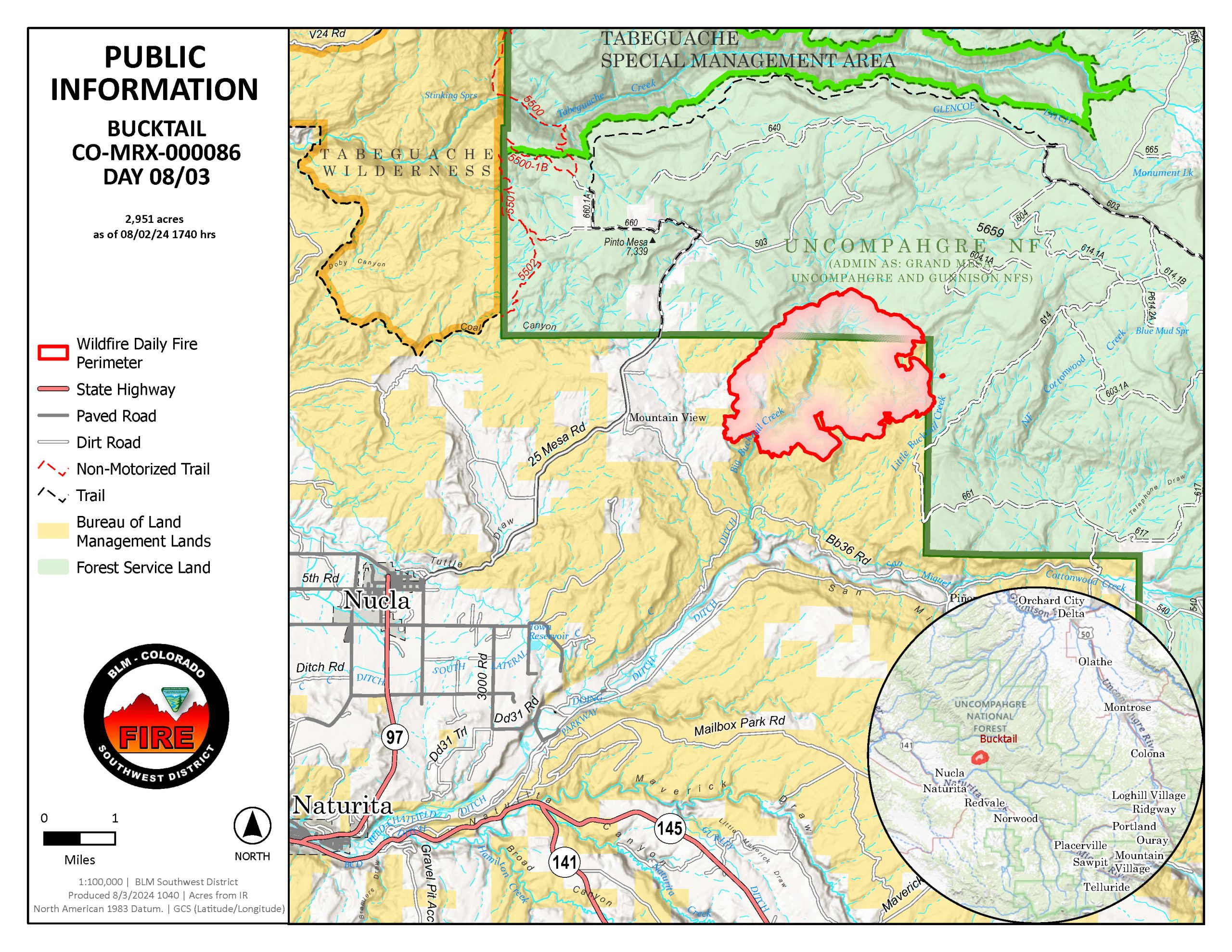
Fire Update – Bucktail August 3, 2024, 7:00 p.m.
Nucla, Colorado,
Start Date: August 1, 2024
Cause: Unknown
Size: 3,155 acres
Percent Contained: 5 %
Resources Assigned: 144 personnel
Crews (3); Engines (3); Dozers (3); Air Resources (3); Heavy Equipment (4)
Yesterday: Firefighters focused their efforts along the western portion of the fire, using a dozer to improve a road to strengthen it as a primary fire line and strengthen the heel of the fire. The fire continued growth primarily to the North and East on National Forest.
Today: Resources are continuing to identify opportunities to secure indirect control lines along 25 Mesa Road to prevent fire spread to the north and east. Temperatures are forecasted to be hot, however monsoon moisture are predicted to keep relative humidities between 15-20%. Scattered showers and thunderstorms will stay mainly over higher terrain north of the fire.
Evacuations: None.
Closures: Road closures are in place within the area of the fire. County Road 25 Mesa is now closed due to emergency operations on the Bucktail Fire. The closure extends from the 25 Mesa/Divide Road intersection to where the pavement starts on 25 Mesa outside of Nucla. Houser Cow Camp Road is closed, down to Old Highway 90 (https://www.facebook.com/MontroseCountySO). A Temporary Flight Restriction (TFR) is in place over the fire area. Wildfires are a No Drone Zone. If You Fly We Can’t Fly https://knowbeforeyoufly.org/home
Smoke Information: Colorado Department of Public Health and Environment (CDPHE) has issued an Air Quality Health Advisory for Wildfire Smoke for Montrose County. Visit https://www.colorado.gov/airquality/colo_advisory.aspx for details. More local air quality information can be found at https://colosmokeoutlook.blogspot.com/ .
–more–
For additional information:
InciWeb: https://inciweb.wildfire.gov/incident-information/coupd-bucktail-fire
Colorado Division of Fire Prevention and Control: https://dfpc.colorado.gov
Bureau of Land Management Southwest Colorado District, Uncompahgre Field Office: https://www.facebook.com/BLMMontroseFireUnit
West Slope Fire Information website: www.WestSlopeFireInfo.com
GMUG Fire Information https://www.facebook.com/GMUGFireInfo
Road Closures Montrose County: https://www.facebook.com/MontroseCountySO
Bucktail Fire Information Hotline: (970) 823-4060
—
Update 8/2/24 10:00am
![]() ROAD CLOSURE ALERT
ROAD CLOSURE ALERT![]()
Houser Cow Camp Road (Forest Service 508) extending down to Old Highway 90 is now closed due to the #BucktailFire. Please avoid the area and do not fly drones. If you have questions, please call the Bucktail Fire Information Line at (970) 823-4060 or visit https://inciweb.wildfire.gov/incident…/coupd-bucktail-fire
Update 8/1/24 3:30pm![]() ROAD CLOSURE
ROAD CLOSURE![]()
25 Mesa road is now closed due to emergency operations on the Bucktail Fire. The closure extends from the 25Mesa/Divide Road intersection to where the pavement starts on 25 Mesa outside of Nucla.
Please avoid the area and do not fly drones.
A wildfire is currently burning in the West End of Montrose County, northeast of Nucla, covering an estimated 200 acres. The fire is not contained and is moving northeast. Montrose County Deputies, Nucla Fire, Naturita Fire, Norwood Fire, BLM, San Miguel County Sheriff’s Deputies, Montrose County Road and Bridge, and CSP are on the scene with heavy aircraft. Please avoid 25 Mesa Road and yield to emergency vehicles. Additionally, do not fly drones, as they interfere with firefighting efforts.