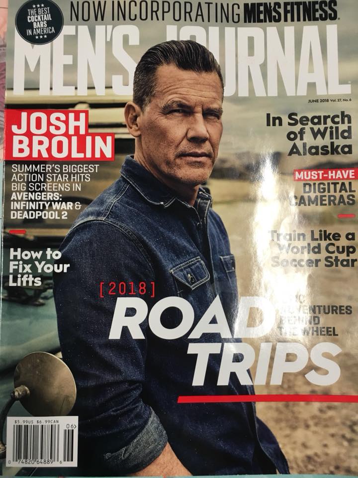
Skip to content
Rimrocker Trail
  • AboutExpand
    • About
    • FAQ
    • Highway 141 Missing Link Project
    • Shavano Gateway Recreation Area
    • PartnersExpand
      • COPMOBA
      • BLM
      • GMUG National Forest
      • Manti La Sal National Forest
    • Montrose County Historical Landmark
  • Maps & GPSExpand
    • Maps and GPS
    • Detailed Directions Montrose to Moab
    • Detailed Directions- Moab to Montrose
    • Rimrocker Trail Elevation Profile
    • Pick Up a Print Map
    • Bypass the Uncompahgre Plateau
  • Side TrailsExpand
    • Interactive Map for Side Trails
    • Bypass the Uncompahgre Plateau Map
    • Dolores River Canyon
    • Monogram Mesa Loop Bull Canyon Tour
    • Long Park Mine Tour
    • Paradox Valley Petroglyph Tour
    • The Wild Horses of Disappointment Valley
    • Uravan, Colorado
    • Scenic & Historic Highway 141 Tour
    • Westcore
  • Visitor InfoExpand
    • Visitor Information
    • Trail Updates
    • Important Travel Info
    • West Slope CO Fire Restriction Info
    • Utah Fire Information
    • OHV/ATV RegsExpand
      • Utah OHV Education Requirement
      • Montrose County OHV/ATV Regulations
      • San Juan County OHV Regulations
    • Manti La Sal Info
    • Montrose
    • Nucla/Naturita
    • Moab
    • West End Trails Alliance
    • Lodging
    • Emergency
  • NewsExpand
    • News
    • Press
  • ContactExpand
    • Contact
    • Tell Us Your Rimrocker Story
    • Get a Bumper Sticker
    • Get a Print Map
  • Logo usage
Rimrocker Trail

Rimrocker Trail News

Home / Rimrocker Trail News - Page 4
6/21/23 Trail Update

6/21/23 Trail Update

June 21, 2023June 21, 2023

Trail update: there’s a road washout after the Tabeguache Creek crossing around 38.35771, -108.69905. Please take the detour from the… Continue Reading 6/21/23 Trail Update

READ MORE 6/21/23 Trail UpdateContinue

The Trail is Open

The Trail is Open

June 12, 2023June 12, 2023

Welcome to Rimrocker Trail Season 2023! We are open for business 😁Don’t forget to send your pictures to pr@montrosecounty.net for… Continue Reading The Trail is Open

READ MORE The Trail is OpenContinue

Trail Update 6/4/23

Trail Update 6/4/23

June 5, 2023June 5, 2023

We are working on it- here’s a quick update with photos from late last week on Divide Road.The Rimrocker Trail… Continue Reading Trail Update 6/4/23

READ MORE Trail Update 6/4/23Continue

Easter Jeep Safari

Easter Jeep Safari

April 7, 2023April 7, 2023

Stop by and see us at Red Rock 4-Wheelers / Easter Jeep Safari vendor show this weekend! Grab some sweet… Continue Reading Easter Jeep Safari

READ MORE Easter Jeep SafariContinue

Utah OHV Education requirement

Utah OHV Education requirement

January 5, 2023January 5, 2023

From the Manti La Sal Nation Forest: Planning to ride your off-highway vehicle (OHV) on the Manti La Sal this… Continue Reading Utah OHV Education requirement

READ MORE Utah OHV Education requirementContinue

Page navigation

Previous PagePrevious 1 2 3 4

Contact Us

Monday - Friday, 8am – 5 pm

E-mail: pr@montrosecounty.net
Phone: +1 (970) 249 7755

Recent posts

  • Rimrocker Trail Now open!
  • Rimrocker Trail Is Almost Open…
  • Rimrocker Trail Closed
  • Montrose County Lifts Fire REstrictions Effective Immediately
  • 8/13/24 Road Closure Info

Trail Updates

  • Rimrocker Trail Now open! May 2, 2025Rimrocker Trail Now open!
  • Rimrocker Trail Is Almost Open… April 24, 2025Rimrocker Trail Is Almost Open...

VISITOR INFO

  • Important Travel Info
  • Moab
  • Montrose
  • Nucla – Naturita
  • Lodging
  • Uravan, Colorado
  • Visitor Information
  • West Slope Fire Restriction Info
  • Utah Fire Info
  • Home
  • Contact
  • Terms of Use
  • Accessibility and Privacy policy
  • Site Map

© 2025 Rimrocker Trail

Facebook Instagram
  • About
    • About
    • FAQ
    • Highway 141 Missing Link Project
    • Shavano Gateway Recreation Area
    • Partners
      • COPMOBA
      • BLM
      • GMUG National Forest
      • Manti La Sal National Forest
    • Montrose County Historical Landmark
  • Maps & GPS
    • Maps and GPS
    • Detailed Directions Montrose to Moab
    • Detailed Directions- Moab to Montrose
    • Rimrocker Trail Elevation Profile
    • Pick Up a Print Map
    • Bypass the Uncompahgre Plateau
  • Side Trails
    • Interactive Map for Side Trails
    • Bypass the Uncompahgre Plateau Map
    • Dolores River Canyon
    • Monogram Mesa Loop Bull Canyon Tour
    • Long Park Mine Tour
    • Paradox Valley Petroglyph Tour
    • The Wild Horses of Disappointment Valley
    • Uravan, Colorado
    • Scenic & Historic Highway 141 Tour
    • Westcore
  • Visitor Info
    • Visitor Information
    • Trail Updates
    • Important Travel Info
    • West Slope CO Fire Restriction Info
    • Utah Fire Information
    • OHV/ATV Regs
      • Utah OHV Education Requirement
      • Montrose County OHV/ATV Regulations
      • San Juan County OHV Regulations
    • Manti La Sal Info
    • Montrose
    • Nucla/Naturita
    • Moab
    • West End Trails Alliance
    • Lodging
    • Emergency
  • News
    • News
    • Press
  • Contact
    • Contact
    • Tell Us Your Rimrocker Story
    • Get a Bumper Sticker
    • Get a Print Map
  • Logo usage
Search