
The Rimrocker Trail runs long stretches through remote areas (that’s why it’s awesome). Large portions of the route are rough, narrow and steep (again, awesome). The route between Nucla and Moab is recommended for 4WD/High Clearance vehicles and OHVs only. When traveling on the Rimrocker, users should plan to be self reliant and recognize that cell phone coverage is very limited.
Recommended travel tips include:
• Travel with another person or vehicle
• Carry maps and know how to use them
• Bring adequate food and water for your planned trip and emergency purposes
• Scout the route on foot if you are uncertain about your ability to navigate a portion in your vehicle
• Wear a helmet when riding a bike or OHV
• Carry first aid and emergency supplies including extra clothing
• Develop riding and driving skills on easier, more accessible routes
• Let a friend or relative know your itinerary
Route Signage
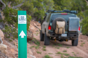 On the ground marking of the Rimrocker Trail consists of fiberglass posts featuring a highly reflective sticker of the Rimrocker Trail logo and a directional arrow.Even though the Web Map Viewer shows a marker symbol for each mile point on the route, on the ground posts do not show the mileage and are not always located at a mile point. Instead, some signage is placed at locations where the trail intersects other roads in order to assist users with staying on the trail. Be aware that not all intersections are marked. It is highly recommended that Rimrocker Trail users adequately plan ahead before getting on the trail and familiarize themselves with the route.